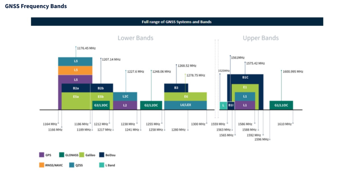
With all our connectivity options, the ability to pinpoint precise locations on the globe has become integral to numerous industries and everyday applications. This capability is powered by sophisticated satellite systems, primarily known as GPS and GNSS. While these acronyms are often used interchangeably, they refer to distinct technologies with unique features and applications. This article aims to elucidate the differences between GPS and GNSS and highlight key functionalities such as location-based services, geofencing, and the role of antennas in these systems.
GPS vs. GNSS: The Core Differences
Global Positioning System (GPS):
- Origin: Developed and maintained by the United States Department of Defense, GPS became fully operational in 1995.
- Constellation: Consists of at least 24 satellites orbiting the Earth, providing global coverage.
- Functionality: Primarily used for navigation, mapping, and timing. GPS devices receive signals from multiple satellites to determine precise locations on Earth.
Global Navigation Satellite System (GNSS):
- Definition: An umbrella term encompassing all satellite navigation systems, including GPS.
- Systems Included:
- GPS (United States)
- GLONASS (Russia)
- Galileo (European Union)
- BeiDou (China)
- Constellation: More extensive than GPS alone, GNSS integrates multiple satellite systems, offering enhanced accuracy and reliability.
- Functionality: Provides similar services to GPS but with improved precision and redundancy due to the availability of additional satellites.

Key Features and Applications
1. Location-Based Services (LBS): LBS leverages GPS or GNSS data to deliver services based on a user’s geographical location. These services include:
- Navigation: Turn-by-turn directions for driving, walking, or biking.
- Mapping: Real-time location tracking on maps for various applications.
- Social Networking: Geotagging and location sharing on social platforms.
- Emergency Services: Dispatching emergency responders to precise locations.
2. Geofencing: Geofencing creates virtual boundaries around a specific geographic area. When a GPS-enabled device enters or exits this area, predefined actions are triggered. Applications of geofencing include:
- Security: Alerting authorities when a person or vehicle enters a restricted area.
- Marketing: Sending promotional messages to customers’ devices when they enter a retail zone.
- Fleet Management: Monitoring and managing the movement of vehicles within designated areas.
3. Precision Agriculture: Farmers utilize GNSS-based systems for precision farming techniques, such as:
- Field Mapping: Creating detailed maps of farm fields for better crop management.
- Automated Machinery: Guiding tractors and other machinery with high precision to optimize planting, fertilizing, and harvesting.
4. Autonomous Vehicles: Self-driving cars and drones rely heavily on GNSS for navigation and operation, requiring accurate and reliable positioning data to function safely and efficiently.
The Role of Antennas
Antennas are crucial components in GPS and GNSS systems, responsible for receiving satellite signals. The quality and design of antennas significantly impact the accuracy and reliability of the location data.
Types of GNSS Antennas: GNSS antennas are available in a variety of sizes and form factors, including chip, flexible PCB, patch, dipole, and helical designs.
- Patch Antennas: Common in portable devices, offering a balance between size and performance.
- Dipole Antennas: One of the most common options, these typically support a wide bandwidth and frequency range and can be passive or active antennas.
- Helical Antennas: These come in a large variety of sizes and can also be passive or active antennas.
Factors Influencing Antenna Performance:
- Gain: Higher gain antennas can receive weaker signals, improving accuracy in challenging environments.
- Multipath Resistance: Antennas designed to minimize multipath interference (reflected signals) offer more accurate positioning.
- Polarization: Circularly polarized antennas are better suited for receiving satellite signals, which are circularly polarized.
Conclusion
Understanding the differences between GPS and GNSS is essential for leveraging their full potential in various applications. While GPS remains a cornerstone of satellite navigation, GNSS offers enhanced accuracy and reliability by incorporating multiple satellite systems. Features like location-based services, geofencing, and the role of advanced antennas underscore the transformative impact of these technologies on modern life. Whether it’s for navigation, precision agriculture, or autonomous vehicles, the integration of GPS and GNSS continues to revolutionize how we interact with the world around us.
Are you looking for a GPS antenna for your application? Use the 5Gstore.com antenna search to assist, or contact the 5Gstore sales team to discuss possible solutions.

